Chicken Mountain: Regional Structural Study
Kuskokwim Belt, southwest Alaska | Independent project, winter 2025–26
Chicken Mountain is a Late Cretaceous (~69 Ma) intrusion-related gold system hosted in folded Kuskokwim Group turbidites, where the Granite Creek Fault meets the dextral Iditarod-Nixon Fault (INF). I compiled published state and federal geologic mapping to build a structural framework for the area and test what controlled its gold-bearing sheeted veins.
245 structural measurements · 11 structural domains · 78 dikes analyzed · 3 quadrangles compiled
The questions
What stress regimes were active when the gold-bearing sheeted veins formed?
What σ1 / σ3 orientations does folding of the Kuskokwim Group imply?
Did the Granite Creek Fault form before or after folding?
The workflow
Compile: merged the GeMS geologic map databases for the Iditarod B-3, B-4 and C-3 quadrangles (Bundtzen et al., 1992) into one QGIS project.
Domain: drew structural domains bounded by mapped faults and changes in fold style, then spatially joined every measurement to its domain.
Analyze: built a Python/Jupyter pipeline for pole-density stereonets, girdle fits, fold axes, superimposed-fold restoration and dike-trend analysis.
Interpret: translated geometry and timing into a deformation history and exploration implications.
Tools: QGIS, GeMS, Python (NumPy, pandas, Matplotlib, mplstereonet), Jupyter, Inkscape, git. The workflow is reproducible: when new mapping comes in, the stereonets and fold axes regenerate in minutes.
Key findings
The Iditarod-Nixon Fault is a structural boundary
North of the INF, Domains 1 and 2 show cylindrical folds with gently plunging ENE axes (3.7° → 062.7° and 3.6° → 056.6°) that run sub-parallel to the fault (053°, vertical). Fold-axis trends rotate about 30° across it. The exploration consequence: the INF separates blocks with different structural histories, so a targeting model from one side shouldn’t be carried across it unchanged.
Dikes follow a long-lived NE corridor
The 78 mapped dikes (three suites) have a median strike of about 050°, within a few degrees of the INF and the fold axes north of it. The dikes cut the folds, so a NE-oriented weakness was available to magma by ~69 Ma. Folds, fault and dikes sharing one orientation point to a long-lived NE structural corridor controlling magma and fluid flow.
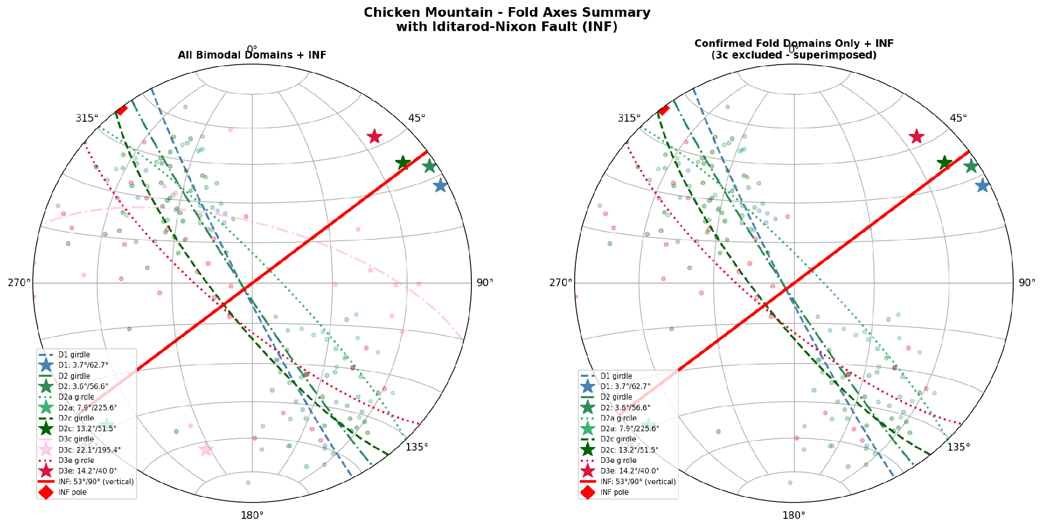
Figure 1. Fold-axis summary with the Iditarod-Nixon Fault (INF; 053°, vertical). Left: all bimodal domains. Right: confirmed fold domains only. Fold axes north of the fault run sub-parallel to the INF; trends rotate about 30° across it.
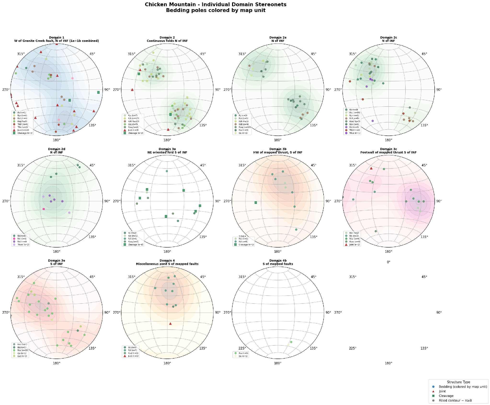
Figure 2. Bedding-pole stereonets for each structural domain (lower-hemisphere, equal-area), colored by map unit, with joints and cleavage by symbol. Bimodal pole clusters north of the INF define cylindrical folds with gently plunging ENE axes.
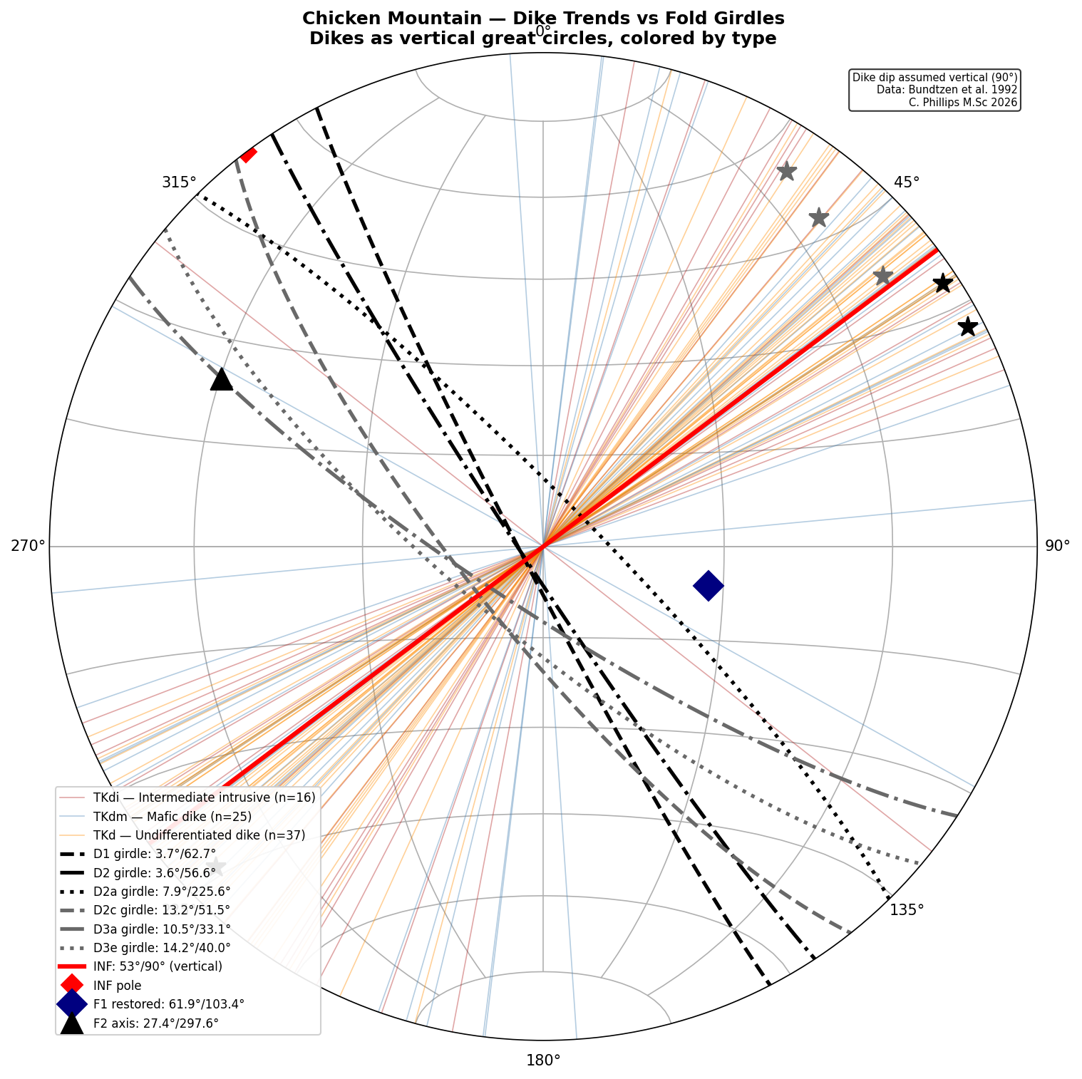
Figure 3. Dike trends versus fold girdles. The 78 mapped dikes (Bundtzen et al., 1992) are plotted as vertical great circles, colored by suite, with the domain fold girdles and the INF (red). Median dike strike is about 050°, sub-parallel to the INF and the northern fold axes.
Deformation history
95–77 Ma: Kuskokwim Group deposition (biostratigraphic age; Miller et al., 2002)
~77–69 Ma: folding of the Kuskokwim Group
~69 Ma: Chicken Mountain pluton and dikes along the NE grain (K-Ar 68.7–70.9 Ma)
~69 Ma (?): Granite Creek Fault; truncates the pluton and is truncated by the INF
69 Ma to present: dextral slip on the INF, which cuts the 69 Ma dikes
Status and next steps
This is an ongoing independent project built entirely on published mapping. The stereonets come from published structural attitudes; the interpretations above are working hypotheses. The next test: Kuskokwim strata wrap around the nearby Horn Mountain intrusion. If Chicken Mountain behaved the same way, the pluton acted as a rigid buttress during folding, and the Granite Creek Fault may mark the rheological contrast at its margin.
Need a structural framework for your project?
I turn legacy and new mapping into a domain-based structural framework, deliver reproducible stereonet and fold analyses, and link structural geometry and timing to drill-target ranking. Reach out at colin@upliftgeological.com.